 14 DAY TRIAL //
 Today's Sahara is a huge desert area, with erratic dunes (called ergs) and plains covered by rugged rocks (called hamada) (below), punctuated by mountains that can be 3,400 m (11,000 feet) high, all in 8.8 million square kilometers (3.3 million square miles) (this is more than Australia), with less than 100 mm of rainfall annually and at great distances one from another with modest bursts of life, the oases. Sahara really means "desert" in Arabic.
But 20 years ago, researchers using radar technology discovered in the depths of the rocks of the wide valleys, a web of "channels", some small, others wider, as broad as the Nile, which represent the dry riverbeds of the rivers that crossed Sahara thousands of years ago. Niger River once originated in Sahara.
The desert of Sahara is supposed to be at least 2.5 million years old. Studies made on the fluctuations of humidity in Sahara during the last 40,000 years revealed that the borders of the desert moved sometimes southward and other times northward and in particular periods, the desert disappeared completely, the sand dunes being replaced by wooded savannas, like those found today in eastern Africa. 18,000 years ago, the last Ice Age had reached its peak and Sahara had moved 400 km (250 mi) south from its current location. But the ice covering Europe, northern Asia and North America melted between 13,000 to 8,000 years ago.
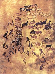
This way, 6,000-8,000 years ago, the rainfall was abundant, and in Sahara flourished the Neolithic culture which left the famous rock paintings found in Tassili n'Ajjer Mountains (above) and other areas of Sahara, depicting crocodiles, ostriches, rhinos, giraffes, buffaloes, hippopotamus and elephants, encountered today only in Africa at South of Sahara, but also oryx antelopes and gazelles. The Sahara was filled with lakes in the region of modern Niger and people hunted antelopes, while its mountains were covered by forests. Archaeologists encountered from hippopotamus and elephant bones to fishing harpoons.
After that, 4,500 years ago, the region turned into the arid desert we know today. In some Saharan mountains or patches, there are some savanna elements still persisting, like crocodiles, hyraxes and different shrub species. But human activity like deforestation, intensive grazing and farming sped up the phenomenon. And Sahara is still expanding southward: since 1900, the desert has gained a fringe over 250 km (155 mi) wide.
The geological history of Sahara showed glacier vestiges in a 450 million old Sahara, during the Ordovician, at the beginning of the life explosion on Earth.
At different geological depths were found fossil algae that confirm that 150-200 million ago, during the Jurassic (the middle dinosaur era), Sahara was covered by an ancient sea, which was in some places 5,000 m (15,000 feet) deep. By 135 millions years ago, dinosaurs roamed Sahara, like the 9 m (30 ft) long carnivorous Afrovenator or the 22 m (73 ft) long sauropod Jobaria.
From that sea, many fossils came, like ammonites (a type of shelled squids), one meter long fishes from extinct groups and ancient huge sea reptiles. Later, during the early Cretaceous (the last dinosaur era), the zone was roamed by different species of dinosaurs. Even today, in the underground of Sahara, at 800 m (2500 feet) depth, there is a subterranean sea of fossil freshwater, compassing 620,000 cubic kilometers (150,000 cubic miles) over a surface of 6.5 million square kilometers (2.3 million square miles).
The exploitation of this water allowed the flourishing the Garamante civilization in the middle of the desert, between 500 BC to 500 AD, till the desert weather worsened too much.
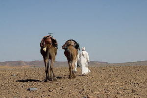
One detail: today the symbol of Sahara is the dromedary camel. This species entered Sahara around the times of Jesus Christ, brought from Arabia. Before that, people of the place used the donkey, originated from the African wild ass, a native of the area.